![]() |
![]() |
![]() |
Date | Name | Type | Location | Lat/Lon | Comment | Acres | Status | TRS | Inc # |
---|---|---|---|---|---|---|---|---|---|
02/02/2023 12:16 | 2023 NFGT Prescribed Fire Support | Resource Order | Davy Crockett National Forest 18551 State Hwy 7 East Kennard, TX 75847 | . | . | . | . | . | UPF-545 WFSE [P] HFDSSE22* (1511) |
02/02/2023 07:41 | West Fork Thermograph Road | Miscellaneous | 3 mi S of Canyonville | 42 53.208, -123 17.502 | . | . | . | 31S R5W Sec 9 | RICC-544 |
01/30/2023 15:20 | Foster Pit | Prescribed Fire | . | 43 13.242, -122 25.128 | 1/31/23 2 acres completed | . | . | 27S R3E Sec 13 | UPF-541 |
01/27/2023 13:10 | CY23 DBNF RX BURNS | Resource Order | . | . | . | . | . | . | RICC-540 HFDSSE22_1511 [P] NFHF02_0802 |
01/17/2023 09:15 | Flat Pile Rd 4760 | Prescribed Fire | . | 43 17.550, -122 36.414 | . | . | . | 26S R2E Sec | UPF-535 |
01/11/2023 16:54 | Conley Creek Hazard Tree | Prescribed Fire | 25-2-27,29 & 33 | 43 21.354, -122 56.718 | 78 acres, 90 piles, 183 tons | . | . | 25S R2W Sec 33 | ROD-532 |
01/11/2023 16:54 | Copeland Divide | Prescribed Fire | Copeland Divide Corner pull-out on the 25.4.12.1 rd | 43 22.140, -123 4.668 | total 165 acres 100 percent completed 01.17.2023 | . | . | 25S R3W Sec 29 | ROD-531 |
01/10/2023 15:22 | Johnnie Springs HP | Prescribed Fire | . | 43 1.596, -122 52.248 | 61 acres planned 1/11/23 | . | . | 29S R1W Sec 30 | UPF-529 |
12/12/2022 07:45 | Mill Pond Lone Pine | Prescribed Fire | 9.9 mi NE of Glide | 43 22.830, -122 56.502 | 12/12 Ignitions 100% complete 9 ac | . | . | 25S R2W Sec 21 | ROD-516 |
12/12/2022 07:17 | Tiller Admin | Prescribed Fire | Tiller | 42 55.452, -122 57.024 | 12/14 5 acres completed. 12/13 10 acres completed. 12/12 6 acres completed. 1/11 4 acres completed. 1/12 4 acres competed | . | . | 30S R2W Sec 33 | UPF-511 |
12/07/2022 07:47 | Glide Path | Prescribed Fire | 18.4 mi E of Myrtle Point | 43 1.692, -123 46.308 | 56 acres planned 12/7 71% completed, 20 acres | . | . | 29S R9W Sec 21 | CBD-506 |
12/06/2022 08:05 | Pop Rocks Hazard Trees | Prescribed Fire | 14 mi NE of Elkton | 43 24.780, -122 52.074 | 25 acres, 27 piles planned 12/06. | . | . | 25S R1W Sec 7 | ROD-497 |
12/01/2022 08:17 | Hunter creek roadside | Prescribed Fire | 5 mi E of Gold Beach | 42 21.738, -124 19.050 | 3 acres. 12/1 1 acre completed, too wet to continue. 02/01 3 acres planned. | . | . | 37S R14W Sec 24 | CBD-488 |
11/29/2022 08:37 | Sudden Oak Death Unit 123 | Prescribed Fire | 5 mi N of Brookings | 42 7.290, -124 16.614 | Planned ignition January 2023. 1.5 acres | . | . | 40S R13W Sec 8 | CBD-476 |
11/29/2022 08:33 | Near Minkey | Prescribed Fire | 12.7 mi SW of Toketee | 43 6.606, -122 37.464 | 8 acres completed 11/29 | . | . | 28S R2E Sec 30 | UPF-475 |
11/29/2022 08:02 | Harrington Creek Hazard Trees | Prescribed Fire | 12 mi NE of North Umpqua Ranger Station | 43 25.536, -122 57.642 | 52 acres, 43 piles. 1/10/23 153 acres, 80 piles completed. | . | . | 25S R2W Sec 5 | ROD-473 |
11/29/2022 07:58 | Sticker Shock Timber Sale | Prescribed Fire | 5 mi ENE of Elkton | 43 38.520, -123 27.828 | 21 acres, 6 piles. | . | . | 22S R6W Sec 19 | ROD-472 |
11/28/2022 10:24 | Sweet Dreams Fire Salvage | Prescribed Fire | 8 mi E of Steamboat Work Center | 43 20.580, -122 54.600 | 289 acres, 144 piles total planned 12/21.. [4 acres, 3 piles completed 11/28] | . | . | 26S R2W Sec 2 | ROD-466 |
11/28/2022 07:54 | SUC | Prescribed Fire | 11.3 mi S of Tiller | 42 45.924, -122 55.968 | 15 acres total. | . | . | 32S R2W Sec 28 | UPF-462 |
11/28/2022 07:39 | Falcon | Prescribed Fire | 19.4 mi ENE of Tiller | 43 0.924, -122 35.328 | 2 acres, 10 piles. | . | . | 29S R2E Sec 28 | UPF-461 |
11/17/2022 08:31 | Bygone Days Reoffer Unit 6-8 | Prescribed Fire | 4 mi WNW of Tiller Ranger Dist | 42 57.288, -123 2.334 | Planned ignition TBD. | . | . | 30S R3W Sec 23 | ROD-452 |
11/16/2022 07:17 | Blue Bowl | Prescribed Fire | 8 mi W of Yoncalla | 43 35.880, -123 25.992 | 127 acres, 180 piles total. Unit 1 - 11 acres completed 11/16. Unit 2 & 5 64 acres, 89 piles completed 100%. | . | . | 23S R6W Sec 5 | ROD-446 |
11/15/2022 09:26 | Puddin Units | Prescribed Fire | 17.5 mi SW of Oakridge | 43 35.202, -122 37.998 | 12/08 units 15H 1 ac., 16 2 ac. complete | . | . | 23S R1E Sec 24 | UPF-445 |
11/14/2022 08:03 | Delay 115 LG | Prescribed Fire | DLRD Hwy 138 near 4785 - 4790 - 4780 roads | 43 15.474, -122 11.196 | 12 acres completed 11/14 - 16 aces completed 11/15 . 01/31/23 1 acre completed. | . | . | 26S R5E Sec 35 | UPF-441 |
11/03/2022 15:40 | White 1 - White 6 - White Reduction | Prescribed Fire | on FS Rd -2301 / 2241 / 2301 | 43 36.222, -122 43.914 | 11/7/22 50 acres completed -- 25 acres completed 11/08/2022. 20 acres completed 11/14 | . | . | 23S R1E Sec 6 | UPF-434 |
11/03/2022 09:13 | Big Hamlin | Prescribed Fire | 9.7 mi ESE of Tiller | 42 51.648, -122 47.298 | 24.5 acres total. 6.5 acres completed on 11/17. | . | . | 31S R1W Sec 8 | UPF-432 |
11/02/2022 17:09 | 2023 OR-UPF AD Training | Resource Order | Do not close | . | WFSUAD23 0627 | . | . | . | UPF-430 (0627) WFSUAD23 |
11/02/2022 15:08 | 2023 OR-UPF Large Fire Support | Resource Order | Do not close | . | P6EK6G23 0615 | . | . | . | UPF-429 (0615) P6EK6G23 |
11/01/2022 13:46 | Smith Suppression Piles | Prescribed Fire | . | 43 7.314, -122 52.992 | 3 ac 11/29 // 0.25 ac 11-9-2022 // 17.5 acres 11-8-2022 // 12 ac 11-2-22. | . | . | 28S R2W Sec 24 | UPF-425 |
09/18/2022 10:00 | Hunter | Wildfire | 3.2 mi SW of Toketee | 43 14.430, -122 28.158 | Out 10/22/2022 Ready to certify InFORM | 0.1 | Contain: 09/18/22 1042 Control: 09/18/22 1103 Out: 10/22/22 1200 |
27S R3E Sec 9 | UPF-386 P6 P2GG (0615) |
07/30/2022 16:17 | Windigo | Wildfire | . | 43 21.798, -122 3.018 | Local IC team. | 1007 | Contain: 10/07/22 1000 Control: 10/07/22 1005 Out: 02/01/23 1000 |
25S R6E Sec 31 | UPF-234 P6 PX45 (0615) |
07/05/2021 17:01 | Jack Fire | Wildfire | Hwy 138 MM 41/42 | 43 19.320, -122 41.136 | Diamond Lake Ranger District | 24165 | Contain: 11/15/21 1200 Control: 12/09/21 0900 |
26S R1E Sec 10 | UPF-265 P6 N40W (0615) |
Agency All Details |
Duty Officer | Duty Officer Night | Engines in Service | Crews in Service | Other Resources | Comments | Updated |
---|---|---|---|---|---|---|---|
North Fire Zone Details | Fhurer Orejuela (BC 6-1) | Fhurer Orejuela (BC 6-1) | 1 | 0 | Coke, Iranzo and Fuels 1 will be burning Puddin 15h and 16 today. | 8-Dec-2022 8:06:47 | |
South Fire Zone Details | Jeremy DeLack - DIV2 | Jeremy DeLack - DIV2 | 0 | 0 | Resources staffing 0630-1700 Mon-Thur. | 10-Jan-2023 8:33:10 | |
Coos Bay District | Spencer Gregory DIV5 | Spencer Gregory DIV5 | 541-464-3399 DO phone | 26-Aug-2022 16:56:11 | |||
Roseburg District | Spencer Gregory DIV5 | Spencer Gregory DIV5 | 541-464-3399 Fire DO | 26-Aug-2022 16:56:22 |
OR-RIC InformationUpdated 3-Feb-2023 7:55:18OR-RIC On Call Dispatcher = Darla Haynes 541-957-3325 Umpqua Duty Officer = Ken Powell BLM Duty Officer = Spencer Gregory (DO Line 541-464-3399) Coos Bay BLM Agency Administrator = Steve Lydick (DM)
Public Use Restrictions - Umpqua NF = Public Use Restrictions - Douglas Forest Protection Association = Public Use Restrictions - Coos Forest Protection Association = Public Use Restrictions - Roseburg BLM = Public Use Restrictions - Coos Bay BLM = National Preparedness Level = 1 Regional Preparedness Level = 1 Local Preparedness Level = 1 OR-RIC Staffing Level = None Shared ResourcesAir Attack =Lead Plane = Recon = Helicopters = Airtankers = Rappellers = Aircraft/Smokejumpers = Wolf Creek IHC = Off season Incident Info OR-RIC WildCAD Site NIFC FTP Server Pocketcard and Fire Weather Current Fire Weather .pdf Fire Danger Spreadsheet .pdf Umpqua National Forest Pocketcard - This card is under review and has not been approved by NWCG at this time. |
Fire Danger and Industrial Fire Precaution Level | ||||
Umpqua NF | DFPA DG-1 |
DFPA DG-2 | DFPA UA-1 | DFPA UA-2 |
![]() |
![]() |
![]() |
![]() |
![]() |
![]() |
![]() |
![]() |
![]() |
![]() |
CFPA CS-1 | CFPA CS-2 |
CFPA CS-4 | CFPA CS-5 | |
![]() |
![]() |
![]() |
![]() |
|
![]() |
![]() |
![]() |
![]() |
Fire Weather Forecast for: | Watches, Warnings or Advisories for: |
---|---|
ORZ617 | Umpqua National Forest (ORZ617) Oregon |
ORZ616 | Umpqua Basin (ORZ616) Oregon |
ORZ615 | South Central Oregon Coast (ORZ615) Oregon |
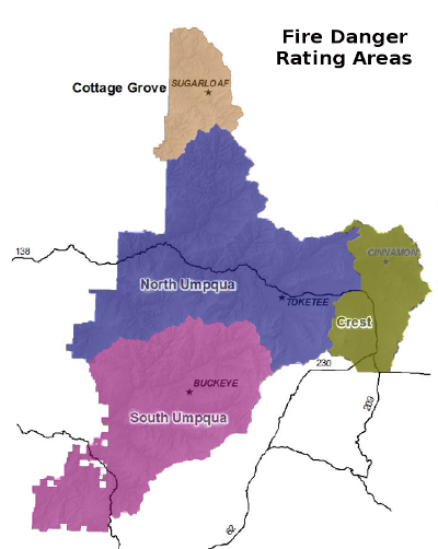
FDRA | 100 HR | 1000 HR | IC | ERC | BI |
---|---|---|---|---|---|
Cottage Grove (observed) | |||||
North Umpqua (observed) | |||||
South Umpqua (observed) | |||||
Crest (observed) | |||||
Cottage Grove (forcasted) | |||||
North Umpqua (forcasted) | |||||
South Umpqua (forcasted) | |||||
Crest (forcasted) |
Resouce | Available | Unavailable | Committed | Rotation | Comments |
---|---|---|---|---|---|
WCIHC | X | 2022 season over | |||
CREW2 SZ T2IA | X | ||||
CREW3 NZ T2IA | X | ||||
WCJCC | X | ||||
WCJCC2 | X | ||||
T2 Umpqua Short | X | ||||
WCJCC5 | X | ||||
UPF E-414 | X | ||||
UPF E-424 | X | ||||
UPF E-325 | X | ||||
UPF E-626 | X | DBNF Fire Support 2022 10/12/22 | |||
UPF E-34 | X | ||||
UPF E-35 | X | ||||
UPF E-465 | X | ||||
UPF E-466 | X | ||||
UPF E-633 | X | ||||
CBD E-6601 | X | ||||
ROD E-4618 | X | Engine assigned to WA-CWC for 2022 Season |
Resouce | Comments |
---|---|
Rob Johnson | HEQO, THSP |
Bret Buxton | ORDM, EQPMt |
Micah Kittel | READt, REAFt |
Engines | Crews | Personnel | Lookouts |
---|---|---|---|
1 | 0 | 3 | 0 |
Position | Name |
---|---|
RICC Main Number 541-957-3325 | ALL |
I/A Dispatcher 541-957-3300 | Sage Swimmer |
Intel/Logistics 541-957-3261 | Darla Haynes |
Dispatch Duty Officer 541-670-7213 | Darla Haynes |
Training Officer 541-440-4930 | Garrett Davis |
Umpqua Deputy Fire Staff Operations 957-3305 | Ken Powell CH2 |
Coos Bay BLM AFMO 541-671-1816 | Spencer Gregory |
Roseburg BLM Acting FMO 541-900-4173 | Spencer Gregory |
Umpqua Forest Duty Officer | Ken Powell CH2 |
Umpqua Deputy Fire Staff Fuels 957-3437 | Sara Billings CH 3 |
Agency | Number of Fires | Acres Burned | ||||
---|---|---|---|---|---|---|
Lightning | Human | Total Fires | Lightning | Human | Total Acres | |
Cottage Grove RD | 0 | 0 | 0 | 0.10 | 0.00 | 0.10 |
Tiller RD | 7 | 2 | 9 | 1.90 | 0.50 | 2.40 |
Diamond Lake RD | 30 | 4 | 34 | 1022.79 | 0.40 | 1023.19 |
North Umpqua RD | 4 | 2 | 6 | 2.80 | 0.20 | 3.00 |
Coos Bay BLM | 0 | 6 | 6 | 0.00 | 5.20 | 5.20 |
Roseburg BLM | 11 | 8 | 19 | 5.80 | 24.50 | 30.30 |
Summary | ||||||
Umpqua National Forest | 41 | 8 | 49 | 1027.59 | 1.10 | 1028.69 |
BLM | 11 | 14 | 25 | 5.80 | 29.70 | 35.50 |
OR-RIC Total | 52 | 22 | 74 | 1033.39 | 30.80 | 1064.19 |